Geolocate

Bhutti topographic map

Click on the map to display elevation.

About this map

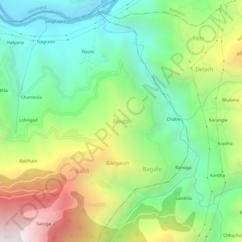
Name: Bhutti topographic map, elevation, terrain.

Location: Bhutti, Kumharsain, Shimla, Himachal Pradesh, 172030, India (31.31132 77.50641 31.35132 77.54641)

Average elevation: 4,695 ft

Minimum elevation: 2,644 ft

Maximum elevation: 8,215 ft

Gear up for your next adventure:

📶Satellite Messenger - Communication device off‑grid
🏔️Mountain Trail Maps - High‑detail maps for popular peaks
🧢Outdoor Hiking Hat - Sun protection hat for outdoor explorers
🪶Fire Starter Kit - Reliable fire starter for survival and camping
🥾Men's Hiking Boots - Durable, waterproof footwear for rugged terrain and steep inclines

As an Amazon Associate, this site earns from qualifying purchases at no extra cost to you.