
Make a donation
Gear up for your next adventure:
As an Amazon Associate, this site earns from qualifying purchases at no extra cost to you.
Sica Sica topographic map
Click on the map to display elevation.
Make a donation
Gear up for your next adventure:
As an Amazon Associate, this site earns from qualifying purchases at no extra cost to you.
Sica Sica
La región presenta un relieve que oscila entre los 4.700 y 3.100 msnm, con una altitud promedio de 3.850 metros sobre el nivel del mar. Presenta pisos ecológicos de planicies, serranías y cabeceras de valle.
Make a donation
Gear up for your next adventure:
As an Amazon Associate, this site earns from qualifying purchases at no extra cost to you.
About this map
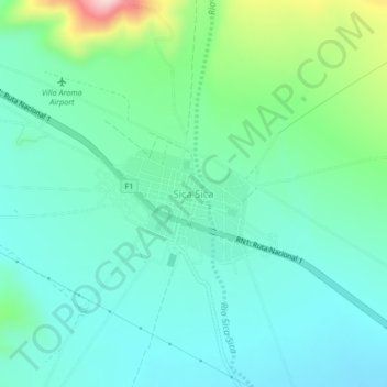
Name: Sica Sica topographic map, elevation, terrain.
Average elevation: 12,900 ft
Minimum elevation: 12,674 ft
Maximum elevation: 13,665 ft
Make a donation
Gear up for your next adventure:
As an Amazon Associate, this site earns from qualifying purchases at no extra cost to you.
Other topographic maps
Click on a map to view its topography, its elevation and its terrain.