
Make a donation
Gear up for your next adventure:
As an Amazon Associate, this site earns from qualifying purchases at no extra cost to you.
Sibagat topographic map
Click on the map to display elevation.
Make a donation
Gear up for your next adventure:
As an Amazon Associate, this site earns from qualifying purchases at no extra cost to you.
Sibagat
Sibagat is located at 8°49′N 125°41′E / 8.82°N 125.69°E / 8.82; 125.69. Elevation of most areas of the municipality sit atop 100 meters above sea level (M.a.s.l.).
Make a donation
Gear up for your next adventure:
As an Amazon Associate, this site earns from qualifying purchases at no extra cost to you.
About this map
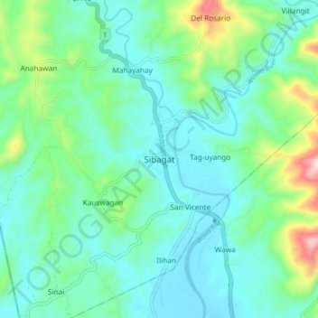
Name: Sibagat topographic map, elevation, terrain.
Location: Sibagat, Agusan del Sur, Caraga, 8503, Philippines (8.77953 125.65313 8.85953 125.73313)
Average elevation: 482 ft
Minimum elevation: 98 ft
Maximum elevation: 1,890 ft
Make a donation
Gear up for your next adventure:
As an Amazon Associate, this site earns from qualifying purchases at no extra cost to you.