Geolocate

Cihangir Mahallesi topographic map

Click on the map to display elevation.

About this map

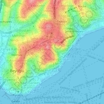
Name: Cihangir Mahallesi topographic map, elevation, terrain.

Location: Cihangir Mahallesi, Beyoğlu, Istanbul, Marmara Region, Turkey (41.03061 28.98292 41.03571 28.98804)

Average elevation: 95 ft

Minimum elevation: -3 ft

Maximum elevation: 308 ft

Gear up for your next adventure:

🌄Hiking Binoculars - Compact binoculars for scenic views and trail spotting
🛠️Outdoor Gear Repair Kit - Essential tools to fix gear on the trail
🧢Outdoor Hiking Hat - Sun protection hat for outdoor explorers
📷Action Cameras - Rugged cameras to document your journeys across rugged terrain
🧥Waterproof Jacket for Hiking - Breathable and rugged rain jacket for outdoor excursions

As an Amazon Associate, this site earns from qualifying purchases at no extra cost to you.