
Make a donation
Gear up for your next adventure:
As an Amazon Associate, this site earns from qualifying purchases at no extra cost to you.
Eastfield topographic map
Click on the map to display elevation.
Make a donation
Gear up for your next adventure:
As an Amazon Associate, this site earns from qualifying purchases at no extra cost to you.
About this map
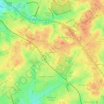
Name: Eastfield topographic map, elevation, terrain.
Average elevation: 738 ft
Minimum elevation: 646 ft
Maximum elevation: 794 ft
Mecklenburg County trails, hiking, mountain biking, running and outdoor activities
Make a donation
Gear up for your next adventure:
As an Amazon Associate, this site earns from qualifying purchases at no extra cost to you.
Other topographic maps
Click on a map to view its topography, its elevation and its terrain.
Providence Plantation
United States > North Carolina > Mecklenburg County > Charlotte
Average elevation: 673 ft
Reedy Creek Regional Park
United States > North Carolina > Mecklenburg County > Charlotte
Average elevation: 751 ft
Tuckaseegee Park
United States > North Carolina > Mecklenburg County > Charlotte
Average elevation: 764 ft
Ballantyne's Backyard
United States > North Carolina > Mecklenburg County > Charlotte
Average elevation: 600 ft
Make a donation
Gear up for your next adventure:
As an Amazon Associate, this site earns from qualifying purchases at no extra cost to you.
Carolina Harbor
United States > North Carolina > Mecklenburg County > Charlotte
Average elevation: 614 ft
Mountainbrook
United States > North Carolina > Mecklenburg County > Charlotte
Average elevation: 663 ft
Griffith Lakes
United States > North Carolina > Mecklenburg County > Charlotte
Average elevation: 801 ft
Make a donation
Gear up for your next adventure:
As an Amazon Associate, this site earns from qualifying purchases at no extra cost to you.
Park on Wilgrove
United States > North Carolina > Mecklenburg County > Charlotte > Lakeland Hills
Average elevation: 761 ft
Providence Plantation
United States > North Carolina > Mecklenburg County > Charlotte
Average elevation: 673 ft
Make a donation
Gear up for your next adventure:
As an Amazon Associate, this site earns from qualifying purchases at no extra cost to you.
Providence Plantation
United States > North Carolina > Mecklenburg County > Charlotte
Average elevation: 673 ft