
Make a donation
Gear up for your next adventure:
As an Amazon Associate, this site earns from qualifying purchases at no extra cost to you.
Tuckaseegee Park topographic map
Click on the map to display elevation.
Make a donation
Gear up for your next adventure:
As an Amazon Associate, this site earns from qualifying purchases at no extra cost to you.
About this map
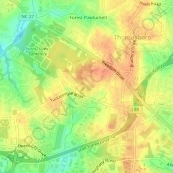
Name: Tuckaseegee Park topographic map, elevation, terrain.
Average elevation: 764 ft
Minimum elevation: 686 ft
Maximum elevation: 810 ft
Mecklenburg County trails, hiking, mountain biking, running and outdoor activities
Make a donation
Gear up for your next adventure:
As an Amazon Associate, this site earns from qualifying purchases at no extra cost to you.
Other topographic maps
Click on a map to view its topography, its elevation and its terrain.
Spring Valley
United States > North Carolina > Mecklenburg County > Charlotte
Average elevation: 659 ft
Make a donation
Gear up for your next adventure:
As an Amazon Associate, this site earns from qualifying purchases at no extra cost to you.
Sharon Colony
United States > North Carolina > Mecklenburg County > Charlotte
Average elevation: 659 ft
Make a donation
Gear up for your next adventure:
As an Amazon Associate, this site earns from qualifying purchases at no extra cost to you.
Carmel Woods
United States > North Carolina > Mecklenburg County > Charlotte
Average elevation: 633 ft
Mountainbrook
United States > North Carolina > Mecklenburg County > Charlotte
Average elevation: 663 ft
Morning Star Acres
United States > North Carolina > Mecklenburg County > Charlotte
Average elevation: 676 ft
Make a donation
Gear up for your next adventure:
As an Amazon Associate, this site earns from qualifying purchases at no extra cost to you.
Orchard Park
United States > North Carolina > Mecklenburg County > Charlotte
Average elevation: 751 ft
Make a donation
Gear up for your next adventure:
As an Amazon Associate, this site earns from qualifying purchases at no extra cost to you.
Old Providence
United States > North Carolina > Mecklenburg County > Charlotte
Average elevation: 630 ft
Montclaire South
United States > North Carolina > Mecklenburg County > Charlotte
Average elevation: 663 ft
Make a donation
Gear up for your next adventure:
As an Amazon Associate, this site earns from qualifying purchases at no extra cost to you.
Coulwood Hills
United States > North Carolina > Mecklenburg County > Charlotte > Coulwood Hills
Average elevation: 699 ft