
Make a donation
Gear up for your next adventure:
As an Amazon Associate, this site earns from qualifying purchases at no extra cost to you.
Börnsen topographic map
Click on the map to display elevation.
Make a donation
Gear up for your next adventure:
As an Amazon Associate, this site earns from qualifying purchases at no extra cost to you.
About this map
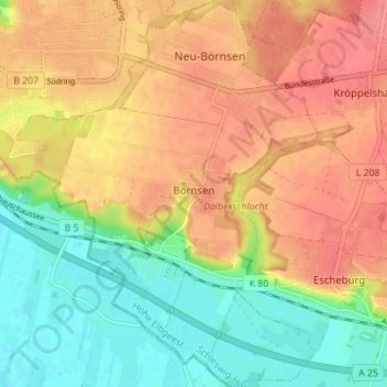
Name: Börnsen topographic map, elevation, terrain.
Average elevation: 115 ft
Minimum elevation: 0 ft
Maximum elevation: 210 ft
Make a donation
Gear up for your next adventure:
As an Amazon Associate, this site earns from qualifying purchases at no extra cost to you.
Other topographic maps
Click on a map to view its topography, its elevation and its terrain.
Fliegenberg
Deutschland > Schleswig-Holstein > Herzogtum Lauenburg > Göldenitz
Average elevation: 161 ft
Geesthacht
Deutschland > Schleswig-Holstein > Herzogtum Lauenburg > Geesthacht > Geesthacht
Die zweite Kirche in Geesthacht war die St.-Peter-Kirche, die nach der Überflutung und Zerstörung der alten Kirche auf einer Anhöhe des Geesthachter Pastorenwerders (wahrscheinlich im Jahre 1261) erbaut wurde. Zum Kirchspiel Geesthacht („Hagede“) gehörten nach den Angaben im Ratzeburger Zehntregister…
Average elevation: 108 ft
Make a donation
Gear up for your next adventure:
As an Amazon Associate, this site earns from qualifying purchases at no extra cost to you.
Wentorf (Amt Sandesneben)
Deutschland > Schleswig-Holstein > Herzogtum Lauenburg > Wentorf
Average elevation: 180 ft
Hellbachtal mit Lottsee, Krebssee und Schwarzsee
Deutschland > Schleswig-Holstein > Herzogtum Lauenburg > Lehmrade
Average elevation: 121 ft
Make a donation
Gear up for your next adventure:
As an Amazon Associate, this site earns from qualifying purchases at no extra cost to you.
Burg Farchau, Marienhöhe
Deutschland > Schleswig-Holstein > Herzogtum Lauenburg > Fredeburg
Auf der Marienhöhe Farchau wurde durch den Ratzeburger Bischof Evermod um 1160 eine Burg angelegt, von der noch Wälle und Grabenreste in der Natur erhalten sind. Die Bischofsburg ging um 1250 kurzzeitig in den Besitz der Herzöge von Sachsen-Lauenburg über, fiel dann aber wieder in den Besitz der Bischöfe…
Average elevation: 92 ft
Kröppelshagen
Deutschland > Schleswig-Holstein > Herzogtum Lauenburg > Kröppelshagen-Fahrendorf
Average elevation: 187 ft
Waldstraße
Deutschland > Schleswig-Holstein > Herzogtum Lauenburg > Klein Pampau > Klein Pampau > Waldstraße
Average elevation: 108 ft
Make a donation
Gear up for your next adventure:
As an Amazon Associate, this site earns from qualifying purchases at no extra cost to you.
Schwarzenbek
Deutschland > Schleswig-Holstein > Herzogtum Lauenburg > Schwarzenbek > Schwarzenbek
Average elevation: 151 ft
Franzhagen
Deutschland > Schleswig-Holstein > Herzogtum Lauenburg > Schulendorf
Average elevation: 115 ft
Köthel (Herzogtum Lauenburg)
Deutschland > Schleswig-Holstein > Herzogtum Lauenburg > Köthel
Average elevation: 157 ft
Make a donation
Gear up for your next adventure:
As an Amazon Associate, this site earns from qualifying purchases at no extra cost to you.