
Thank you for supporting this site ❤️
Make a donation
Make a donation
Gear up for your next adventure:
As an Amazon Associate, this site earns from qualifying purchases at no extra cost to you.
Papias topographic map
Click on the map to display elevation.
Thank you for supporting this site ❤️
Make a donation
Make a donation
Gear up for your next adventure:
As an Amazon Associate, this site earns from qualifying purchases at no extra cost to you.
About this map
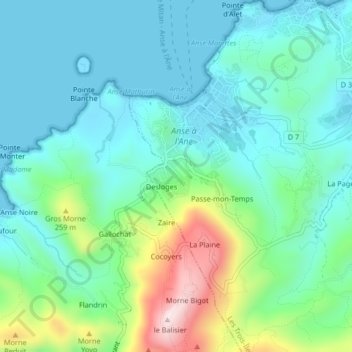
Name: Papias topographic map, elevation, terrain.
Location: Papias, Les Trois-Îlets, Le Marin, Martinique, 97229, France (14.51156 -61.08817 14.55156 -61.04817)
Average elevation: 344 ft
Minimum elevation: -3 ft
Maximum elevation: 1,453 ft
Thank you for supporting this site ❤️
Make a donation
Make a donation
Gear up for your next adventure:
As an Amazon Associate, this site earns from qualifying purchases at no extra cost to you.