Geolocate

Springfield topographic map

Click on the map to display elevation.

About this map

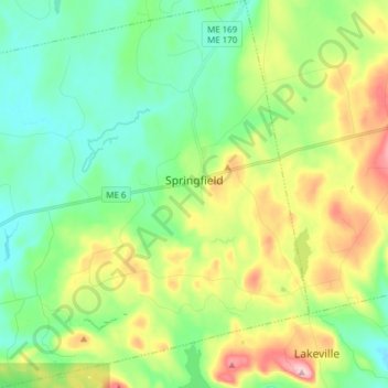
Name: Springfield topographic map, elevation, terrain.

Location: Springfield, Penobscot County, Maine, United States (45.33861 -68.24132 45.44586 -68.09033)

Average elevation: 545 ft

Minimum elevation: 308 ft

Maximum elevation: 1,037 ft

Penobscot County trails, hiking, mountain biking, running and outdoor activities

Other topographic maps

Click on a map to view its topography, its elevation and its terrain.

Bangor Hill

United States > Maine > Penobscot County > Orono

Average elevation: 203 ft

Hudson Hill

United States > Maine > Penobscot County > Hudson

Average elevation: 253 ft

Blackcap

United States > Maine > Penobscot County > Eddington

Average elevation: 571 ft

Sugar Island

United States > Maine > Penobscot County > Greenbush

Average elevation: 135 ft

Tiger Rips

United States > Maine > Penobscot County

Average elevation: 741 ft

State Island

United States > Maine > Penobscot County

Average elevation: 482 ft

Lincoln

United States > Maine > Penobscot County > Lincoln

Average elevation: 272 ft

Gear up for your next adventure:

🏥Hiking First Aid Kits - Comprehensive medical kits for remote trail injuries
🛌Ultralight Sleeping Bags - Compact down bags for cold nights in the wilderness
🎒Outdoor Daypacks - Lightweight backpacks designed for carrying maps and essential gear
🔦LED Headlamp - Bright and durable LED headlamp for night navigation
🧭Hiking Compass - Precision compass for reliable navigation in the wilderness

As an Amazon Associate, this site earns from qualifying purchases at no extra cost to you.