Geolocate

Sugpon topographic map

Click on the map to display elevation.

About this map

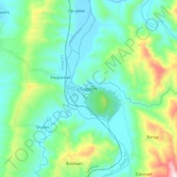
Name: Sugpon topographic map, elevation, terrain.

Location: Sugpon, Ilocos Sur, Ilocos Region, 2717, Philippines (16.80446 120.47672 16.88446 120.55672)

Average elevation: 728 ft

Minimum elevation: 138 ft

Maximum elevation: 2,490 ft

Other topographic maps

Click on a map to view its topography, its elevation and its terrain.

Bessang Pass

Philippines > Ilocos Sur

Average elevation: 4,518 ft

Gear up for your next adventure:

🥾Women's Hiking Boots - Top-rated trail boots with ankle support and superior grip
🛌Ultralight Sleeping Bags - Compact down bags for cold nights in the wilderness
🧭Map Reading Tools - Tools and kits for map navigation
🗺️Topographic Maps - Detailed topo maps for hiking, exploring and outdoor navigation
🌄Hiking Binoculars - Compact binoculars for scenic views and trail spotting

As an Amazon Associate, this site earns from qualifying purchases at no extra cost to you.