Geolocate

San Isidro topographic map

Click on the map to display elevation.

About this map

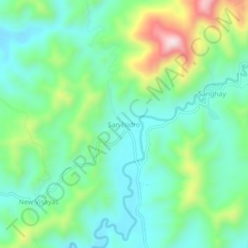
Name: San Isidro topographic map, elevation, terrain.

Location: San Isidro, Mati, Davao Oriental, Davao Region, Philippines (6.94897 126.10295 6.98897 126.14295)

Average elevation: 709 ft

Minimum elevation: 285 ft

Maximum elevation: 1,759 ft

Gear up for your next adventure:

🥘Titanium Cookware - Durable, featherlight pots and pans for backpacking
🥾Women's Hiking Boots - Top-rated trail boots with ankle support and superior grip
🪶Wildlife Field Guides - Learn animal tracking and species ID
🚁Photography Drones - Capture stunning aerial views of landforms and topography
🧭Compass with Lanyard - Easy‑carry compass for navigation

As an Amazon Associate, this site earns from qualifying purchases at no extra cost to you.