Geolocate

Alto da Rua XV topographic map

Click on the map to display elevation.

About this map

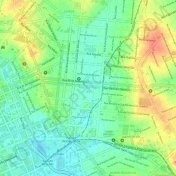
Name: Alto da Rua XV topographic map, elevation, terrain.

Location: Alto da Rua XV, Curitiba, Região Geográfica Imediata de Curitiba, Região Metropolitana de Curitiba, Região Geográfica Intermediária de Curitiba, Paraná, Região Sul, Brasil (-25.43341 -49.25978 -25.42235 -49.24163)

Average elevation: 2,986 ft

Minimum elevation: 2,907 ft

Maximum elevation: 3,084 ft

Other topographic maps

Click on a map to view its topography, its elevation and its terrain.

Rio Atuba

Brasil > Paraná > Curitiba

Average elevation: 2,949 ft

Rio Belém

Brasil > Paraná > Curitiba

Average elevation: 3,163 ft

Rio Barigui

Brasil > Paraná > Curitiba

Average elevation: 3,002 ft

Gear up for your next adventure:

🗻Climbing Gear Basics - Essential gear for beginner climbers
🧭Orienteering Set - Complete compass and map reading kit
🥾Men's Hiking Boots - Durable, waterproof footwear for rugged terrain and steep inclines
🧭Map Reading Tools - Tools and kits for map navigation
📡GPS Antenna Upgrade - Enhance GPS reception in remote terrain

As an Amazon Associate, this site earns from qualifying purchases at no extra cost to you.