
Make a donation
Gear up for your next adventure:
As an Amazon Associate, this site earns from qualifying purchases at no extra cost to you.
Blantyre topographic map
Click on the map to display elevation.
Make a donation
Gear up for your next adventure:
As an Amazon Associate, this site earns from qualifying purchases at no extra cost to you.
Blantyre
From 1876 to 1905, urban development in Blantyre was confined to three distinct areas within 2 km of each other: Blantyre Mission, Mandala (European commercial venture), and the government zone and commercial centre triangle marked by Haile Selassie Road, Glyn Jones Road and Hannover Street. In Limbe development started in 1906 following the establishment of the Shire Highlands Railways Company headquarters and repair and servicing facilities and Imperial Tobacco Group (ITG) packaging and tobacco grading factory nearby. As a result of the establishment of these large operations, easy accessibility and flat topography, Limbe experienced a development boom of Indian wholesale and retail shops. By 1910 Limbe town surpassed Blantyre town. Low- and medium-density housing for the European and Asian staff was in Mpingwe, ITG and Mudi in Limbe and in Mount Pleasant, Sunnyside, Namiwawa, Kabula and Mandala in Blantyre. The Indian shops included accommodation at the rear or on the top floor. High-density housing for the African workforce was far away except the Chiwembe compound in Limbe.
Make a donation
Gear up for your next adventure:
As an Amazon Associate, this site earns from qualifying purchases at no extra cost to you.
About this map
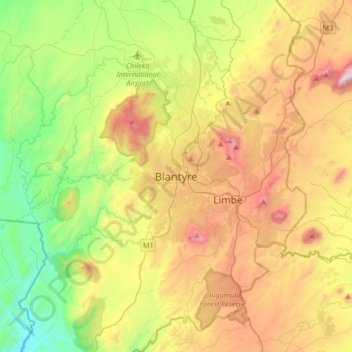
Name: Blantyre topographic map, elevation, terrain.
Location: Blantyre, Southern Region, Malawi, Malawi (-15.94625 34.84357 -15.62625 35.16357)
Average elevation: 2,861 ft
Minimum elevation: 833 ft
Maximum elevation: 5,833 ft
Make a donation
Gear up for your next adventure:
As an Amazon Associate, this site earns from qualifying purchases at no extra cost to you.