Geolocate

Netheravon topographic map

Click on the map to display elevation.

About this map

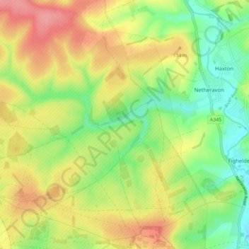
Name: Netheravon topographic map, elevation, terrain.

Location: Netheravon, Wiltshire, England, United Kingdom (51.21480 -1.86731 51.24701 -1.77970)

Average elevation: 381 ft

Minimum elevation: 246 ft

Maximum elevation: 525 ft

Other topographic maps

Click on a map to view its topography, its elevation and its terrain.

Eysey

United Kingdom > England > Wiltshire > Cricklade

Average elevation: 266 ft

Reybridge

United Kingdom > England > Wiltshire > Lacock

Average elevation: 213 ft

Nomansland

United Kingdom > England > Wiltshire

Average elevation: 223 ft

Hawkeridge

United Kingdom > England > Wiltshire > Hawkeridge

Average elevation: 187 ft

Botley Hill

United Kingdom > England > Wiltshire

Average elevation: 584 ft

Jugg's Wood

United Kingdom > England > Wiltshire > Froxfield

Average elevation: 430 ft

Deptford

United Kingdom > England > Wiltshire > Wylye > Deptford

Average elevation: 361 ft

Gear up for your next adventure:

📱Heavy-Duty Phone Cases - Drop-proof and waterproof protection for outdoor navigation
🎒Trekking Poles - Sturdy poles for balance and stability on rough terrain
🔥Plasma Lighters - Windproof lighters that work in any weather condition
🥄Camping Utensil Set - Lightweight utensils for outdoor meals
🔭Compact Binoculars - HD vision for scouting terrain and identifying distant landmarks

As an Amazon Associate, this site earns from qualifying purchases at no extra cost to you.