Geolocate

Botley Hill topographic map

Click on the map to display elevation.

About this map

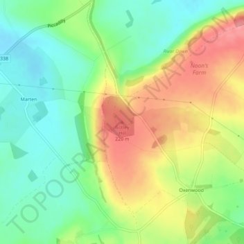
Name: Botley Hill topographic map, elevation, terrain.

Location: Botley Hill, Wiltshire, England, SN8 3NF, United Kingdom (51.33792 -1.57656 51.33802 -1.57646)

Average elevation: 584 ft

Minimum elevation: 453 ft

Maximum elevation: 755 ft

Other topographic maps

Click on a map to view its topography, its elevation and its terrain.

Marden

United Kingdom > England > Wiltshire

Average elevation: 456 ft

Broad Chalke

United Kingdom > England > Wiltshire

Average elevation: 440 ft

Melksham

United Kingdom > England > Wiltshire > Melksham

Average elevation: 135 ft

Ramsbury

United Kingdom > England > Wiltshire

Average elevation: 538 ft

Berwick St. John

United Kingdom > England > Wiltshire

Average elevation: 551 ft

Ashton Keynes

United Kingdom > England > Wiltshire

Average elevation: 285 ft

Edington

United Kingdom > England > Wiltshire

Average elevation: 436 ft

Netheravon

United Kingdom > England > Wiltshire

Average elevation: 381 ft

Malmesbury

United Kingdom > England > Wiltshire > Malmesbury

Average elevation: 276 ft

Downton

United Kingdom > England > Wiltshire

Average elevation: 243 ft

Hullavington

United Kingdom > England > Wiltshire > Hullavington

Average elevation: 325 ft

Jugg's Wood

United Kingdom > England > Wiltshire > Froxfield

Average elevation: 430 ft

Tisbury

United Kingdom > England > Wiltshire

Average elevation: 417 ft

Gear up for your next adventure:

🪑Ultralight Camp Chairs - Portable seating for resting after a long day of mapping
🛌Ultralight Sleeping Bags - Compact down bags for cold nights in the wilderness
🧭Pro Hiking Compasses - High-accuracy liquid-filled compasses for topographic orientation
🔊Portable Camp Speaker - Music and alerts at camp
👓Polarized Sunglasses - Outdoor sunglasses for glare reduction

As an Amazon Associate, this site earns from qualifying purchases at no extra cost to you.