Geolocate

Curug topographic map

Click on the map to display elevation.

About this map

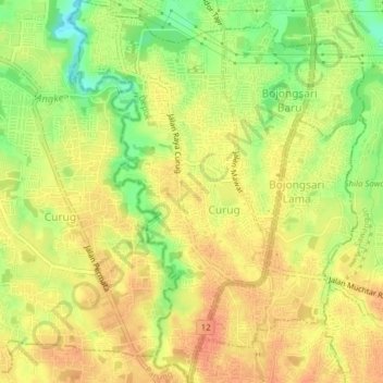
Name: Curug topographic map, elevation, terrain.

Location: Curug, Bojongsari, Depok, Bogor, West Java, Java, Indonesia (-6.41628 106.72164 -6.37770 106.74239)

Average elevation: 279 ft

Minimum elevation: 187 ft

Maximum elevation: 331 ft

Other topographic maps

Click on a map to view its topography, its elevation and its terrain.

Alun-alun Sukamaju

Indonesia > West Java > Bogor > Depok > Sukamaju

Average elevation: 328 ft

Jatijajar

Indonesia > West Java > Bogor > Depok

Average elevation: 312 ft

Kalibaru

Indonesia > West Java > Bogor > Depok

Average elevation: 335 ft

Cimpaeun

Indonesia > West Java > Bogor > Depok

Average elevation: 358 ft

Situ Sidomukti

Indonesia > West Java > Bogor > Depok > Sukamaju

Average elevation: 318 ft

Bakti Jaya

Indonesia > West Java > Bogor > Depok

Average elevation: 269 ft

Krukut

Indonesia > West Java > Bogor > Depok > Krukut

Average elevation: 210 ft

Harjamukti

Indonesia > West Java > Bogor > Depok

Average elevation: 253 ft

Mekar Jaya

Indonesia > West Java > Bogor > Depok

Average elevation: 269 ft

Gear up for your next adventure:

📡GPS Antenna Upgrade - Enhance GPS reception in remote terrain
📷Action Cameras - Rugged cameras to document your journeys across rugged terrain
🪓Survival Multi‑Tool - Versatile tool for camp and trail tasks
📱Solar Portable Charger - Solar power bank for charging devices off‑grid
📷Action Camera - Capture your outdoor adventures in HD

As an Amazon Associate, this site earns from qualifying purchases at no extra cost to you.