Geolocate

Limbon topographic map

Click on the map to display elevation.

About this map

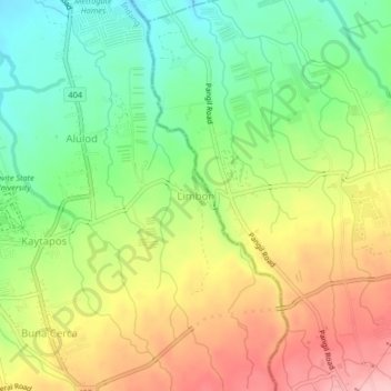
Name: Limbon topographic map, elevation, terrain.

Location: Limbon, Indang, Cavite, Calabarzon, 4122, Philippines (14.18035 120.88177 14.22035 120.92177)

Average elevation: 1,037 ft

Minimum elevation: 801 ft

Maximum elevation: 1,319 ft

Other topographic maps

Click on a map to view its topography, its elevation and its terrain.

Bancod

Philippines > Cavite > Indang

Average elevation: 791 ft

Kaytapos

Philippines > Cavite > Indang

Average elevation: 1,010 ft

Banaba Cerca

Philippines > Cavite > Indang

Average elevation: 728 ft

Buna Cerca

Philippines > Cavite > Indang

Average elevation: 1,093 ft

Banaba Cerca

Philippines > Cavite > Indang

Average elevation: 728 ft

Kaytapos

Philippines > Cavite > Indang

Average elevation: 1,010 ft

Mataas na Lupa (Checkpoint)

Philippines > Cavite > Indang

Average elevation: 738 ft

Mataas na Lupa (Checkpoint)

Philippines > Cavite > Indang

Average elevation: 738 ft

Gear up for your next adventure:

🎒Trekking Poles - Sturdy poles for balance and stability on rough terrain
👟Men's Trail Runners - Lightweight footwear for fast-paced exploration and light hiking
🏥Hiking First Aid Kits - Comprehensive medical kits for remote trail injuries
🧷Carabiner Set - Durable clips for gear attachment
🧭Compass with Lanyard - Easy‑carry compass for navigation

As an Amazon Associate, this site earns from qualifying purchases at no extra cost to you.