
Lonlay-l'Abbaye topographic map
Interactive map
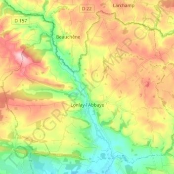
Click on the map to display elevation.
About this map
Name: Lonlay-l'Abbaye topographic map, elevation, terrain.
Average elevation: 702 ft
Minimum elevation: 404 ft
Maximum elevation: 1,070 ft
La topographie est très marquée et contribue fortement à la définition de l’urbanisation du territoire. Les altitudes varient de 129 m au sud du territoire à 320 m NGF à hauteur du Haut du Bois, soit un dénivelé proche de 200 mètres. Le centre bourg est implanté dans le fonds de la vallée de l’Égrenne avec une orientation nord-sud. En amont du bourg, cette vallée apparaît relativement encaissée et a tendance à s’ouvrir au sud du territoire.
Other topographic maps
Click on a map to view its topography, its elevation and its terrain.
Larchamp
France > Normandie > Orne > Tinchebray-Bocage
Larchamp, Tinchebray-Bocage, Argentan, Orne, Normandie, France métropolitaine, 61800, France
Average elevation: 833 ft
La Lande-Patry
France > Normandie > Orne > La Lande-Patry
La Lande-Patry, Argentan, Orne, Normandie, France métropolitaine, 61100, France
Average elevation: 656 ft
La Perrière
France > Normandie > Orne > Belforêt-en-Perche
La Perrière, Belforêt-en-Perche, Mortagne-au-Perche, Orne, Normandie, France métropolitaine, 61360, France
Average elevation: 571 ft