
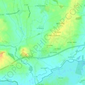
Hauterive topographic map
Interactive map
Click on the map to display elevation.
About this map
Name: Hauterive topographic map, elevation, terrain.
Average elevation: 476 ft
Minimum elevation: 436 ft
Maximum elevation: 541 ft
Other topographic maps
Click on a map to view its topography, its elevation and its terrain.
Larchamp
France > Normandie > Orne > Tinchebray-Bocage
Larchamp, Tinchebray-Bocage, Argentan, Orne, Normandie, France métropolitaine, 61800, France
Average elevation: 833 ft
La Lande-Patry
France > Normandie > Orne > La Lande-Patry
La Lande-Patry, Argentan, Orne, Normandie, France métropolitaine, 61100, France
Average elevation: 656 ft
La Perrière
France > Normandie > Orne > Belforêt-en-Perche
La Perrière, Belforêt-en-Perche, Mortagne-au-Perche, Orne, Normandie, France métropolitaine, 61360, France
Average elevation: 571 ft
Lonlay-l'Abbaye
Lonlay-l'Abbaye, Argentan, Orne, Normandie, France métropolitaine, 61700, France
Average elevation: 702 ft