
Pluck topographic map
Click on the map to display elevation.
About this map
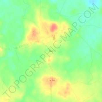
Name: Pluck topographic map, elevation, terrain.
Location: Pluck, Polk County, Texas, United States (30.99130 -94.76354 31.03130 -94.72354)
Average elevation: 200 ft
Minimum elevation: 118 ft
Maximum elevation: 299 ft
Polk County trails, hiking, mountain biking, running and outdoor activities
Other topographic maps
Click on a map to view its topography, its elevation and its terrain.
Lake Livingston
United States > Texas > Polk County
The earthfill dam has a concrete spillway and was designed by Brown and Root, Incorporated (now KBR, Inc). The dam has a spillway crest elevation of 99 feet (30 m) above mean sea level. The average base width of the dam's earthen embankment is 310 feet (94 m) wide. The spillway is designed and constructed to…
Average elevation: 217 ft
Onalaska
United States > Texas > Polk County
The city's terrain is characterized by gently rolling hills and piney woods typical of the East Texas Timberlands region. Elevations within Onalaska range from approximately 128 feet (39 m) to 253 feet (77 m) above sea level, with an average elevation around 161 feet (49 m).
Average elevation: 161 ft
Lake Livingston
United States > Texas > Polk County
The earthfill dam has a concrete spillway and was designed by Brown and Root, Incorporated (now KBR, Inc). The dam has a spillway crest elevation of 99 feet (30 m) above mean sea level. The average base width of the dam's earthen embankment is 310 feet (94 m) wide. The spillway is designed and constructed to…
Average elevation: 217 ft