
Make a donation
Gear up for your next adventure:
As an Amazon Associate, this site earns from qualifying purchases at no extra cost to you.
Ostrava topographic map
Click on the map to display elevation.
Make a donation
Gear up for your next adventure:
As an Amazon Associate, this site earns from qualifying purchases at no extra cost to you.
About this map
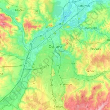
Name: Ostrava topographic map, elevation, terrain.
Average elevation: 804 ft
Minimum elevation: 633 ft
Maximum elevation: 1,165 ft
Make a donation
Gear up for your next adventure:
As an Amazon Associate, this site earns from qualifying purchases at no extra cost to you.
Other topographic maps
Click on a map to view its topography, its elevation and its terrain.
Praděd
Czechia > Moravia-Silesia > Moravian-Silesian Region > Malá Morávka
Average elevation: 4,242 ft
Make a donation
Gear up for your next adventure:
As an Amazon Associate, this site earns from qualifying purchases at no extra cost to you.
Sibérie
Czechia > Moravia-Silesia > Moravian-Silesian Region > Frenstat pod Radhostem
Average elevation: 1,473 ft
Josefovice
Czechia > Moravia-Silesia > Moravian-Silesian Region > Klimkovice
Average elevation: 876 ft