Geolocate

Pointe Goodenough topographic map

Interactive map

Click on the map to display elevation.

About this map

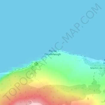
Name: Pointe Goodenough topographic map, elevation, terrain.

Location: Pointe Goodenough, New Amsterdam Island, Saint Paul and New Amsterdam Islands, French Southern and Antarctic Lands, France (-37.79319 77.55636 -37.79309 77.55646)

Average elevation: 131 ft

Minimum elevation: 0 ft

Maximum elevation: 666 ft

Other topographic maps

Click on a map to view its topography, its elevation and its terrain.

Mont Pâris

France > French Southern and Antarctic Lands

Mont Pâris, Kerguelen Archipelago, French Southern and Antarctic Lands, France

Average elevation: 837 ft

Possession Island

France > French Southern and Antarctic Lands

Possession Island, French Southern and Antarctic Lands, France

Average elevation: 43 ft

New Amsterdam Island

France > French Southern and Antarctic Lands

New Amsterdam Island, Saint Paul and New Amsterdam Islands, French Southern and Antarctic Lands, France

Average elevation: 610 ft

Cataractes

France > French Southern and Antarctic Lands

Cataractes, Kerguelen Archipelago, French Southern and Antarctic Lands, France

Average elevation: 102 ft

Crozet Archipelago

France > French Southern and Antarctic Lands

Crozet Archipelago, French Southern and Antarctic Lands, France

Average elevation: 7 ft

Penguin Island

France > French Southern and Antarctic Lands

Penguin Island, Crozet Archipelago, French Southern and Antarctic Lands, France

Average elevation: 157 ft

Bassas da India

France > French Southern and Antarctic Lands

Bassas da India, Scattered Islands in the Indian Ocean, French Southern and Antarctic Lands, France

Average elevation: 0 ft

Kerguelen Archipelago

France > French Southern and Antarctic Lands

Kerguelen Archipelago, French Southern and Antarctic Lands, France

Average elevation: 125 ft