Geolocate

Province of Coronel Portillo topographic map

Click on the map to display elevation.

About this map

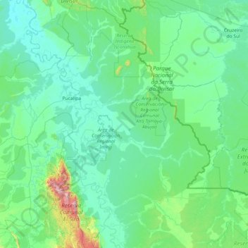
Name: Province of Coronel Portillo topographic map, elevation, terrain.

Location: Province of Coronel Portillo, Ucayali, Peru (-10.09385 -75.45304 -7.26205 -72.93999)

Average elevation: 830 ft

Minimum elevation: 400 ft

Maximum elevation: 7,772 ft

Other topographic maps

Click on a map to view its topography, its elevation and its terrain.

La Restinga

Peru > Ucayali > Yarinacocha

Average elevation: 466 ft

Pucallpa

Peru > Ucayali

Average elevation: 479 ft

Pucallpa

Peru > Ucayali

Average elevation: 479 ft

2 de Mayo

Peru > Ucayali > Yarinacocha

Average elevation: 489 ft

Puerto Azul

Peru > Ucayali > Padre Abad

Average elevation: 1,109 ft

Puerto Azul

Peru > Ucayali > Padre Abad

Average elevation: 1,109 ft

Pucallpillo

Peru > Ucayali > Manantay

Average elevation: 469 ft

Roya

Peru > Ucayali

Average elevation: 518 ft

Pucallpa

Peru > Ucayali

Average elevation: 479 ft

Puerto Callao

Peru > Ucayali > Yarinacocha > Puerto Callao

Average elevation: 482 ft

Mar de Plata

Peru > Ucayali > Neshuya > Mar de Plata

Average elevation: 735 ft

Mar de Plata

Peru > Ucayali > Neshuya

Average elevation: 679 ft

Gear up for your next adventure:

🧭Outdoor Navigation Book - Learn advanced navigation skills
🚗GPS Dash Cams - Record your scenic drives through mountain passes and canyons
🛡️Bear Spray Outdoor - Protection in bear country hikes
🛰️Handheld GPS Units - Professional satellite navigators for precise backcountry mapping
📷Action Cameras - Rugged cameras to document your journeys across rugged terrain

As an Amazon Associate, this site earns from qualifying purchases at no extra cost to you.