
Make a donation
Gear up for your next adventure:
As an Amazon Associate, this site earns from qualifying purchases at no extra cost to you.
Sint-Juliaan topographic map
Click on the map to display elevation.
Make a donation
Gear up for your next adventure:
As an Amazon Associate, this site earns from qualifying purchases at no extra cost to you.
Sint-Juliaan
Sint-Juliaan ligt in Zandlemig Vlaanderen op een hoogte van 19 meter. Doorheen het centrum van Sint-Juliaan stroomt de Hanebeek die ontspringt in Zonnebeke. De beek stroomt verder tot in Langemark, waar deze overgaat in de Steenbeek. De Hanebeek is gelegen in het Stroomgebied van de IJzer.
Make a donation
Gear up for your next adventure:
As an Amazon Associate, this site earns from qualifying purchases at no extra cost to you.
About this map
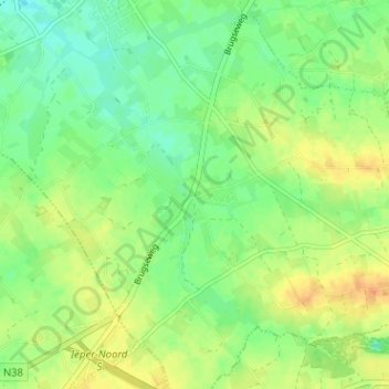
Name: Sint-Juliaan topographic map, elevation, terrain.
Average elevation: 62 ft
Minimum elevation: 13 ft
Maximum elevation: 121 ft
Make a donation
Gear up for your next adventure:
As an Amazon Associate, this site earns from qualifying purchases at no extra cost to you.