Geolocate

Daun topographic map

Click on the map to display elevation.

About this map
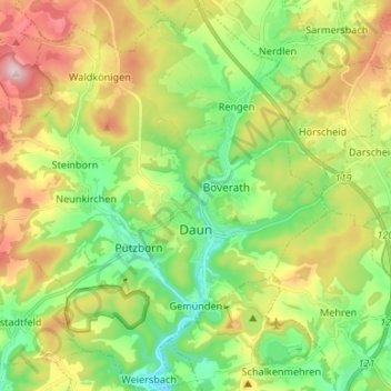
Name: Daun topographic map, elevation, terrain.

Location: Daun, Landkreis Vulkaneifel, Rhineland-Palatinate, 54550, Germany (50.16101 6.74411 50.24611 6.87554)

Average elevation: 1,591 ft

Minimum elevation: 1,148 ft

Maximum elevation: 2,283 ft

Other topographic maps

Click on a map to view its topography, its elevation and its terrain.
Gear up for your next adventure:

🔋Solar Power Banks - Keep your GPS and phone charged in remote wilderness areas
🧦Merino Wool Socks - Moisture-wicking, blister-preventing socks for long treks
⛺Backpacking Tent - Lightweight and durable tent for multi‑day hikes
🔭Compact Binoculars - HD vision for scouting terrain and identifying distant landmarks
🎒Day Hiking Backpack - Lightweight backpack perfect for day trips and outdoor adventures

As an Amazon Associate, this site earns from qualifying purchases at no extra cost to you.