
Make a donation
Gear up for your next adventure:
As an Amazon Associate, this site earns from qualifying purchases at no extra cost to you.
Zilsdorf topographic map
Click on the map to display elevation.
Make a donation
Gear up for your next adventure:
As an Amazon Associate, this site earns from qualifying purchases at no extra cost to you.
About this map
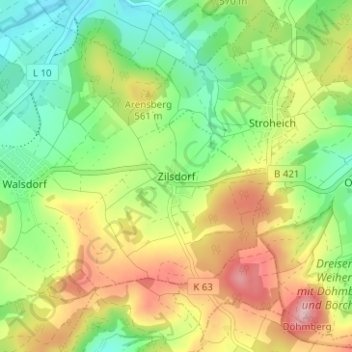
Name: Zilsdorf topographic map, elevation, terrain.
Average elevation: 1,703 ft
Minimum elevation: 1,427 ft
Maximum elevation: 2,090 ft
Make a donation
Gear up for your next adventure:
As an Amazon Associate, this site earns from qualifying purchases at no extra cost to you.
Other topographic maps
Click on a map to view its topography, its elevation and its terrain.
Make a donation
Gear up for your next adventure:
As an Amazon Associate, this site earns from qualifying purchases at no extra cost to you.
Birgel
Germany > Rhineland-Palatinate > Landkreis Vulkaneifel
The municipality belongs to the Kalkeifel (“Limestone Eifel”) and lies on the southern edge of the Dollendorf Limestone Basin (Dollendorfer Kalkmulde). The elevation ranges from about 400 m above sea level on the Kyll at Crumpsmühle to about 526 m above sea level at the Hirzberg (mountain).
Average elevation: 1,476 ft
Niederbettingen
Germany > Rhineland-Palatinate > Landkreis Vulkaneifel > Hillesheim
Average elevation: 1,434 ft
Make a donation
Gear up for your next adventure:
As an Amazon Associate, this site earns from qualifying purchases at no extra cost to you.
Dockweiler
Germany > Rhineland-Palatinate > Landkreis Vulkaneifel
The municipality lies on the watershed between the Ahr and the Moselle in the heart of the Vulkaneifel, a part of the Eifel known for its volcanic history, geographical and geological features, and even ongoing activity today, including gases that sometimes well up from the earth. Dockweiler lies in the north…
Average elevation: 1,831 ft
Make a donation
Gear up for your next adventure:
As an Amazon Associate, this site earns from qualifying purchases at no extra cost to you.
Make a donation
Gear up for your next adventure:
As an Amazon Associate, this site earns from qualifying purchases at no extra cost to you.
Feusdorf
Germany > Rhineland-Palatinate > Landkreis Vulkaneifel
Feusdorf's area is 442 ha all together, of which cropfields and open water make up 78 ha, greenbelt and heath 203 ha, private property 26 ha, woods 105 ha, public roadways 26 ha and other lands 4 ha. Flurbereinigung was undertaken in 1968. Feusdorf lies at an elevation of 450 to 565 m above sea level.
Average elevation: 1,650 ft
Make a donation
Gear up for your next adventure:
As an Amazon Associate, this site earns from qualifying purchases at no extra cost to you.
Hallschlag
Germany > Rhineland-Palatinate > Landkreis Vulkaneifel > Hallschlag
Average elevation: 1,857 ft