
332 topographic map
Click on the map to display elevation.
About this map
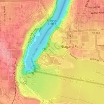
Name: 332 topographic map, elevation, terrain.
Average elevation: 554 ft
Minimum elevation: 318 ft
Maximum elevation: 686 ft
Niagara County trails, hiking, mountain biking, running and outdoor activities
Other topographic maps
Click on a map to view its topography, its elevation and its terrain.
Love Canal
United States > New York > Niagara County > City of Niagara Falls > Black Creek Village
Residents were suspicious of black fluid that flowed out of the Love Canal. For years, residents had complained about odors and substances in their yards or the public playgrounds. Finally, the city acted and hired a consultant, Calspan Corporation, to do a far-reaching study. In 1977, a harsh winter storm…
Average elevation: 577 ft