
Haslet topographic map
Click on the map to display elevation.
About this map
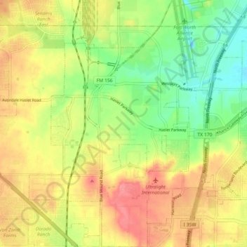
Name: Haslet topographic map, elevation, terrain.
Location: Haslet, Tarrant County, Texas, United States (32.92417 -97.36684 32.99920 -97.30980)
Average elevation: 745 ft
Minimum elevation: 630 ft
Maximum elevation: 853 ft
Tarrant County trails, hiking, mountain biking, running and outdoor activities
Other topographic maps
Click on a map to view its topography, its elevation and its terrain.
Will Rogers Memorial Center
United States > Texas > Tarrant County > Fort Worth
Average elevation: 594 ft