
Thank you for supporting this site ❤️
Make a donation
Make a donation
Gear up for your next adventure:
As an Amazon Associate, this site earns from qualifying purchases at no extra cost to you.
Battagram District topographic map
Click on the map to display elevation.
Thank you for supporting this site ❤️
Make a donation
Make a donation
Gear up for your next adventure:
As an Amazon Associate, this site earns from qualifying purchases at no extra cost to you.
About this map
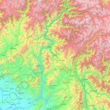
Name: Battagram District topographic map, elevation, terrain.
Location: Battagram District, Khyber Pakhtunkhwa, 21040, Pakistan (33.97217 72.32121 35.37217 73.72121)
Average elevation: 6,640 ft
Minimum elevation: 935 ft
Maximum elevation: 17,559 ft
Thank you for supporting this site ❤️
Make a donation
Make a donation
Gear up for your next adventure:
As an Amazon Associate, this site earns from qualifying purchases at no extra cost to you.
Other topographic maps
Click on a map to view its topography, its elevation and its terrain.
Gantar Khwar
Pakistan > Khyber Pakhtunkhwa > Battagram District > Allai Tehsil > Palang
Average elevation: 6,831 ft