
Thank you for supporting this site ❤️
Make a donation
Make a donation
Gear up for your next adventure:
As an Amazon Associate, this site earns from qualifying purchases at no extra cost to you.
Frochaux topographic map
Click on the map to display elevation.
Thank you for supporting this site ❤️
Make a donation
Make a donation
Gear up for your next adventure:
As an Amazon Associate, this site earns from qualifying purchases at no extra cost to you.
About this map
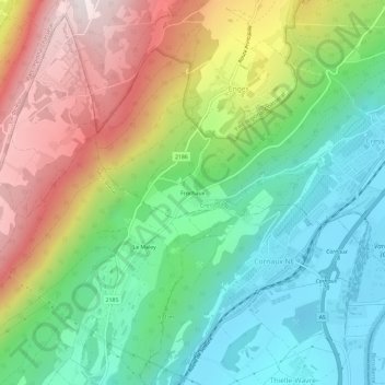
Name: Frochaux topographic map, elevation, terrain.
Location: Frochaux, Cressier (NE), Neuchâtel, 2088, Suisse (47.02540 6.98637 47.06540 7.02637)
Average elevation: 2,372 ft
Minimum elevation: 1,394 ft
Maximum elevation: 3,960 ft
Thank you for supporting this site ❤️
Make a donation
Make a donation
Gear up for your next adventure:
As an Amazon Associate, this site earns from qualifying purchases at no extra cost to you.