
Rumbeck topographic map
Click on the map to display elevation.
About this map
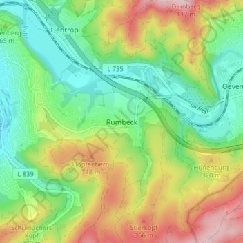
Name: Rumbeck topographic map, elevation, terrain.
Average elevation: 906 ft
Minimum elevation: 600 ft
Maximum elevation: 1,385 ft
Other topographic maps
Click on a map to view its topography, its elevation and its terrain.
Bruchhausen
Deutschland > Nordrhein-Westfalen > Hochsauerlandkreis > Arnsberg
Average elevation: 676 ft
59823
Deutschland > Nordrhein-Westfalen > Hochsauerlandkreis > Arnsberg > Oeventrop
Average elevation: 1,040 ft
59757
Deutschland > Nordrhein-Westfalen > Hochsauerlandkreis > Arnsberg > Herdringen
Average elevation: 850 ft
Oeventrop
Deutschland > Nordrhein-Westfalen > Hochsauerlandkreis > Arnsberg
Average elevation: 1,010 ft
Niedereimer
Deutschland > Nordrhein-Westfalen > Hochsauerlandkreis > Arnsberg
Ein Naturdenkmal, das auch Aufnahme in das Dorfwappen fand, war eine angeblich mehr als tausend Jahre alte dicke Eiche, die noch zu Beginn des 20. Jahrhunderts die drittgrößte Eiche im deutschen Kaiserreich war. In Manneshöhe hatte sie einen Umfang von neun Metern. Der Baum wurde 1853 von König Friedrich…
Average elevation: 817 ft
Haarsche Siepen
Deutschland > Nordrhein-Westfalen > Hochsauerlandkreis > Arnsberg
Average elevation: 1,076 ft