Geolocate

Batalay topographic map

Click on the map to display elevation.

About this map

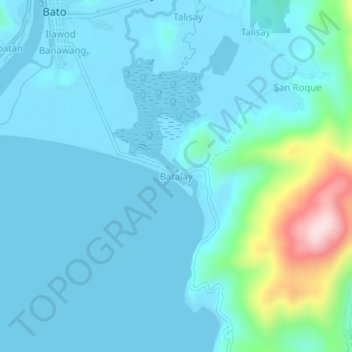
Name: Batalay topographic map, elevation, terrain.

Location: Batalay, Bato, Catanduanes, Bicol Region, 4801, Philippines (13.56932 124.29203 13.60932 124.33203)

Average elevation: 151 ft

Minimum elevation: -13 ft

Maximum elevation: 1,096 ft

Gear up for your next adventure:

🥾Hiking Shoes - Durable and comfortable shoes for trail hiking
🪶LED Camping Lantern - Bright lantern for camp lighting
📦Gear Storage Bags - Organize and protect outdoor equipment
🥄Camping Utensil Set - Lightweight utensils for outdoor meals
❄️Traction Cleats - Prevent slips on icy trails during winter hikes

As an Amazon Associate, this site earns from qualifying purchases at no extra cost to you.