Geolocate

Dalash topographic map

Click on the map to display elevation.

About this map

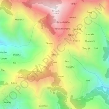
Name: Dalash topographic map, elevation, terrain.

Location: Dalash, Ani, Kullu, Himachal Pradesh, 172025, India (31.36713 77.41417 31.40713 77.45417)

Average elevation: 5,912 ft

Minimum elevation: 3,881 ft

Maximum elevation: 8,192 ft

Gear up for your next adventure:

🎒Trekking Poles - Sturdy poles for balance and stability on rough terrain
🧴Hand Sanitizer - Keep hands clean while hiking
🚗GPS Dash Cams - Record your scenic drives through mountain passes and canyons
☀️Outdoor Sunscreen - High protection sunscreen for outdoor activities
🧤Tactile Hiking Gloves - Keep hands warm while operating GPS and smartphone screens

As an Amazon Associate, this site earns from qualifying purchases at no extra cost to you.