Geolocate

Valderrobres / Vall de Roures topographic map

Click on the map to display elevation.

👉 Easily get elevation data in JSON, GeoTIFF and KML formats using Elevation API
Thank you for supporting this site ❤️
Make a donation

About this map

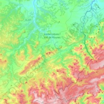
Name: Valderrobres / Vall de Roures topographic map, elevation, terrain.

Location: Valderrobres / Vall de Roures, Matarraña / Matarranya, Teruel, Aragon, 44580, Spain (40.71825 0.07270 40.95428 0.22313)

Average elevation: 2,441 ft

Minimum elevation: 1,322 ft

Maximum elevation: 4,528 ft

Gear up for your next adventure:

🎒Trail Energy Bars - High‑calorie bars for hiking energy
🚁Photography Drones - Capture stunning aerial views of landforms and topography
🪓Survival Multi‑Tool - Versatile tool for camp and trail tasks
🪶Multi‑Purpose Knife - Useful blade for camp and trail
🕶️GPS Smartphone Mount - Secure mount for phone navigation

As an Amazon Associate, this site earns from qualifying purchases at no extra cost to you.