Geolocate

Bantan topographic map

Click on the map to display elevation.

👉 Easily get elevation data in JSON, GeoTIFF and KML formats using Elevation API
Thank you for supporting this site ❤️
Make a donation

About this map

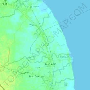
Name: Bantan topographic map, elevation, terrain.

Location: Bantan, Bataan, Central Luzon, 2102, Philippines (14.62851 120.55152 14.66851 120.59152)

Average elevation: 16 ft

Minimum elevation: 0 ft

Maximum elevation: 49 ft

Gear up for your next adventure:

👟Men's Trail Runners - Lightweight footwear for fast-paced exploration and light hiking
🧥Waterproof Jacket for Hiking - Breathable and rugged rain jacket for outdoor excursions
🗺️Topographic Maps - Detailed topo maps for hiking, exploring and outdoor navigation
🛰️Handheld GPS Units - Professional satellite navigators for precise backcountry mapping
🪶Paracord Bracelet - Survival bracelet with built‑in tools

As an Amazon Associate, this site earns from qualifying purchases at no extra cost to you.