
Thank you for supporting this site ❤️
Make a donation
Make a donation
Gear up for your next adventure:
As an Amazon Associate, this site earns from qualifying purchases at no extra cost to you.
Sersi topographic map
Click on the map to display elevation.
Thank you for supporting this site ❤️
Make a donation
Make a donation
Gear up for your next adventure:
As an Amazon Associate, this site earns from qualifying purchases at no extra cost to you.
About this map
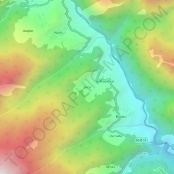
Name: Sersi topographic map, elevation, terrain.
Location: Sersi, Ukhimath, Rudraprayag, Uttarakhand, 246471, India (30.58414 78.99455 30.62414 79.03455)
Average elevation: 6,371 ft
Minimum elevation: 4,541 ft
Maximum elevation: 9,324 ft
Thank you for supporting this site ❤️
Make a donation
Make a donation
Gear up for your next adventure:
As an Amazon Associate, this site earns from qualifying purchases at no extra cost to you.