
Wausaukee topographic map
Click on the map to display elevation.
About this map
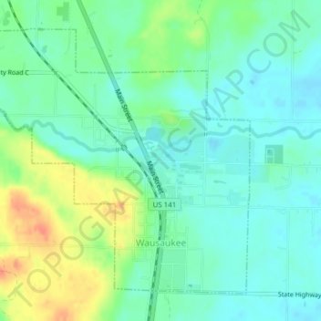
Name: Wausaukee topographic map, elevation, terrain.
Location: Wausaukee, Marinette County, Wisconsin, United States (45.36671 -87.97231 45.38900 -87.94164)
Average elevation: 758 ft
Minimum elevation: 709 ft
Maximum elevation: 853 ft
Marinette County trails, hiking, mountain biking, running and outdoor activities
Other topographic maps
Click on a map to view its topography, its elevation and its terrain.
Goll
United States > Wisconsin > Marinette County > Town of Wagner
Goll is located at the intersection of County Trunk Highway X and Old Rail Road (formerly Right of Way Road), at an elevation of 702 feet (214 m). It is connected by road to Wagner to the north, Middle Inlet to the west, and Wisconsin Highway 180 to the east. Goll Road runs obliquely to the east of the former…
Average elevation: 689 ft
Marinette County Beech Forest State Natural Area
United States > Wisconsin > Marinette County
Average elevation: 1,217 ft
McAllister
United States > Wisconsin > Marinette County
McAllister is located at the intersection of Wisconsin Highway 180 and County Highway JJ 11.5 miles (18.5 km) east-southeast of Wausaukee at an elevation of 692 feet (211 m). It is connected by road to Wausaukee to the west, Packard to the north, Wagner to the south, and Wallace, Michigan, to the east via a…
Average elevation: 689 ft
Long Slide Falls County Park
United States > Wisconsin > Marinette County > Town of Niagra
Average elevation: 945 ft