Geolocate

Goodman topographic map

Click on the map to display elevation.

About this map

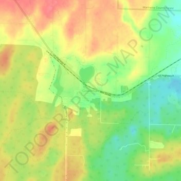
Name: Goodman topographic map, elevation, terrain.

Location: Goodman, Town of Goodman, Marinette County, Wisconsin, 54125, United States (45.61135 -88.37345 45.65135 -88.33345)

Average elevation: 1,421 ft

Minimum elevation: 1,299 ft

Maximum elevation: 1,522 ft

Other topographic maps

Click on a map to view its topography, its elevation and its terrain.

Crivitz

United States > Wisconsin > Marinette County

Average elevation: 692 ft

Wausaukee

United States > Wisconsin > Marinette County

Average elevation: 758 ft

Marinette

United States > Wisconsin > Marinette County

Average elevation: 597 ft

Town of Niagra

United States > Wisconsin > Marinette County

Average elevation: 1,014 ft

Crivitz

United States > Wisconsin > Marinette County > Crivitz

Average elevation: 692 ft

Peshtigo

United States > Wisconsin > Marinette County

Average elevation: 610 ft

Wausaukee

United States > Wisconsin > Marinette County > Wausaukee

Average elevation: 758 ft

Gear up for your next adventure:

🥄Camping Utensil Set - Lightweight utensils for outdoor meals
🏫Relief Map Kits - Hands-on tools for teaching landforms and elevation
🛌Ultralight Sleeping Bags - Compact down bags for cold nights in the wilderness
🧦Hiking Socks - Comfortable socks to prevent blisters on long hikes
🛰️Handheld GPS Units - Professional satellite navigators for precise backcountry mapping

As an Amazon Associate, this site earns from qualifying purchases at no extra cost to you.