
Make a donation
Gear up for your next adventure:
As an Amazon Associate, this site earns from qualifying purchases at no extra cost to you.
Strobl topographic map
Click on the map to display elevation.
Make a donation
Gear up for your next adventure:
As an Amazon Associate, this site earns from qualifying purchases at no extra cost to you.
Strobl
Située sur la rive est du lac Wolfgangsee, à 542 m d'altitude, la municipalité est nichée dans les montagnes du massif du Salzkammergut, vis-à-vis de Sankt Wolfgang.
Make a donation
Gear up for your next adventure:
As an Amazon Associate, this site earns from qualifying purchases at no extra cost to you.
About this map
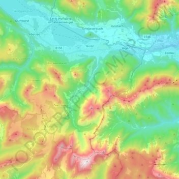
Name: Strobl topographic map, elevation, terrain.
Location: Strobl, Bezirk Salzburg-Umgebung, Salzbourg, 5350, Autriche (47.62489 13.33512 47.73855 13.55087)
Average elevation: 3,278 ft
Minimum elevation: 1,598 ft
Maximum elevation: 6,594 ft
Make a donation
Gear up for your next adventure:
As an Amazon Associate, this site earns from qualifying purchases at no extra cost to you.
Other topographic maps
Click on a map to view its topography, its elevation and its terrain.
Waldprechting
Autriche > Salzbourg > Bezirk Salzburg-Umgebung > Seekirchen am Wallersee
Average elevation: 1,811 ft
Make a donation
Gear up for your next adventure:
As an Amazon Associate, this site earns from qualifying purchases at no extra cost to you.