
Make a donation
Gear up for your next adventure:
As an Amazon Associate, this site earns from qualifying purchases at no extra cost to you.
Poppenweiler topographic map
Click on the map to display elevation.
Make a donation
Gear up for your next adventure:
As an Amazon Associate, this site earns from qualifying purchases at no extra cost to you.
About this map
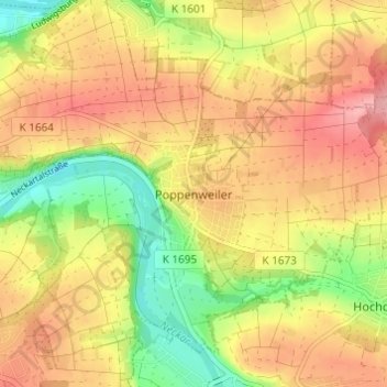
Name: Poppenweiler topographic map, elevation, terrain.
Average elevation: 853 ft
Minimum elevation: 633 ft
Maximum elevation: 1,030 ft
Make a donation
Gear up for your next adventure:
As an Amazon Associate, this site earns from qualifying purchases at no extra cost to you.
Other topographic maps
Click on a map to view its topography, its elevation and its terrain.
Pflugfelden
Deutschland > Baden-Württemberg > Landkreis Ludwigsburg > Ludwigsburg
Average elevation: 1,033 ft
Eglosheim
Deutschland > Baden-Württemberg > Landkreis Ludwigsburg > Ludwigsburg
Average elevation: 879 ft
Neckarweihingen
Deutschland > Baden-Württemberg > Landkreis Ludwigsburg > Ludwigsburg
Average elevation: 797 ft
Oßweil
Deutschland > Baden-Württemberg > Landkreis Ludwigsburg > Ludwigsburg
Average elevation: 879 ft
Make a donation
Gear up for your next adventure:
As an Amazon Associate, this site earns from qualifying purchases at no extra cost to you.
Favoritepark
Deutschland > Baden-Württemberg > Landkreis Ludwigsburg > Ludwigsburg
Average elevation: 892 ft
Poppenweiler
Deutschland > Baden-Württemberg > Landkreis Ludwigsburg > Ludwigsburg > Poppenweiler
Average elevation: 860 ft
Make a donation
Gear up for your next adventure:
As an Amazon Associate, this site earns from qualifying purchases at no extra cost to you.