
Make a donation
Gear up for your next adventure:
As an Amazon Associate, this site earns from qualifying purchases at no extra cost to you.
Cinctorres topographic map
Click on the map to display elevation.
Make a donation
Gear up for your next adventure:
As an Amazon Associate, this site earns from qualifying purchases at no extra cost to you.
About this map
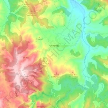
Name: Cinctorres topographic map, elevation, terrain.
Average elevation: 3,091 ft
Minimum elevation: 2,343 ft
Maximum elevation: 4,127 ft
Make a donation
Gear up for your next adventure:
As an Amazon Associate, this site earns from qualifying purchases at no extra cost to you.
Other topographic maps
Click on a map to view its topography, its elevation and its terrain.
La Mata
Spain > Valencian Community > el Baix Segura / La Vega Baja > Torrevieja
Average elevation: 16 ft
Make a donation
Gear up for your next adventure:
As an Amazon Associate, this site earns from qualifying purchases at no extra cost to you.
Cap de la Nau
Spain > Valencian Community > Xàbia / Jávea
Atop the headland, at an elevation of 120 metres (390 ft), stands the Cap de la Nau lighthouse, providing an important aid to navigation.
Average elevation: 105 ft
Platja del Cabanyal - Les Arenes
Spain > Valencian Community > Comarca de València > Valencia
Average elevation: 7 ft
Make a donation
Gear up for your next adventure:
As an Amazon Associate, this site earns from qualifying purchases at no extra cost to you.
Playa Flamenca I
Spain > Valencian Community > el Baix Segura / La Vega Baja del Segura > Orihuela > Urbanización La Zenia
Average elevation: 82 ft
La Mata
Spain > Valencian Community > el Baix Segura / La Vega Baja > Torrevieja
Average elevation: 16 ft
Make a donation
Gear up for your next adventure:
As an Amazon Associate, this site earns from qualifying purchases at no extra cost to you.
Make a donation
Gear up for your next adventure:
As an Amazon Associate, this site earns from qualifying purchases at no extra cost to you.
Make a donation
Gear up for your next adventure:
As an Amazon Associate, this site earns from qualifying purchases at no extra cost to you.
Raiguero de Bonanza
Spain > Valencian Community > el Baix Segura / La Vega Baja > Orihuela
Average elevation: 456 ft
Coma Breco
Spain > Valencian Community > el Poble Nou de Benitatxell / Benitachell
Average elevation: 482 ft
Make a donation
Gear up for your next adventure:
As an Amazon Associate, this site earns from qualifying purchases at no extra cost to you.
Make a donation
Gear up for your next adventure:
As an Amazon Associate, this site earns from qualifying purchases at no extra cost to you.
Balsa de riego goteo Pozo la Esperanza
Spain > Valencian Community > Nàquera / Náquera
Average elevation: 302 ft
Make a donation
Gear up for your next adventure:
As an Amazon Associate, this site earns from qualifying purchases at no extra cost to you.
Castell de Benissili
Spain > Valencian Community > la Vall de Gallinera > Benissili
Average elevation: 2,064 ft
Castell de Benissili
Spain > Valencian Community > la Vall de Gallinera > Benissili
Average elevation: 2,064 ft
Make a donation
Gear up for your next adventure:
As an Amazon Associate, this site earns from qualifying purchases at no extra cost to you.
la Garrotxa
Spain > Valencian Community > Castelló / Castellón > Cervera del Maestre
Average elevation: 896 ft
Cabo Roig
Spain > Valencian Community > el Baix Segura / La Vega Baja del Segura > Orihuela
Average elevation: 30 ft
Make a donation
Gear up for your next adventure:
As an Amazon Associate, this site earns from qualifying purchases at no extra cost to you.
Dehesa de Campoamor
Spain > Valencian Community > el Baix Segura / La Vega Baja del Segura > Orihuela
Average elevation: 92 ft
Make a donation
Gear up for your next adventure:
As an Amazon Associate, this site earns from qualifying purchases at no extra cost to you.
Make a donation
Gear up for your next adventure:
As an Amazon Associate, this site earns from qualifying purchases at no extra cost to you.
Make a donation
Gear up for your next adventure:
As an Amazon Associate, this site earns from qualifying purchases at no extra cost to you.
Urbanización Doña Pepa
Spain > Valencian Community > el Baix Segura / La Vega Baja del Segura > Rojales
Average elevation: 79 ft
Torre de la Horadada
Spain > Valencian Community > el Baix Segura / La Vega Baja del Segura > Pilar de la Horadada
Average elevation: 16 ft
Make a donation
Gear up for your next adventure:
As an Amazon Associate, this site earns from qualifying purchases at no extra cost to you.
Plaza Antigua Fábrica Fernando Diago
Spain > Valencian Community > Castelló / Castellón > Castelló de la Plana
Average elevation: 115 ft
Make a donation
Gear up for your next adventure:
As an Amazon Associate, this site earns from qualifying purchases at no extra cost to you.
Vila-real
Spain > Valencian Community > Castelló / Castellón > Vila-real > Vila-real
Average elevation: 138 ft
Villa Martín
Spain > Valencian Community > el Baix Segura / La Vega Baja del Segura > Orihuela > Villa Martín
Average elevation: 243 ft
Bassa de Ferrara
Spain > Valencian Community > Castelló / Castellón > la Pobla Tornesa
Average elevation: 1,565 ft
Make a donation
Gear up for your next adventure:
As an Amazon Associate, this site earns from qualifying purchases at no extra cost to you.
Make a donation
Gear up for your next adventure:
As an Amazon Associate, this site earns from qualifying purchases at no extra cost to you.