Geolocate

Cap de la Nau topographic map

Click on the map to display elevation.

Cap de la Nau

Atop the headland, at an elevation of 120 metres (390 ft), stands the Cap de la Nau lighthouse, providing an important aid to navigation.

Wikipedia (CC-BY-SA 3.0)

About this map

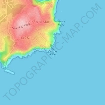
Name: Cap de la Nau topographic map, elevation, terrain.

Location: Cap de la Nau, Balcón al Mar, Xàbia / Jávea, la Marina Alta, Alacant / Alicante, Valencian Community, 03738, Spain (38.73185 0.23100 38.73195 0.23110)

Average elevation: 105 ft

Minimum elevation: -16 ft

Maximum elevation: 541 ft

Other topographic maps

Click on a map to view its topography, its elevation and its terrain.

Gear up for your next adventure:

😴Insulated Sleeping Pads - Compact and warm pads for high-elevation camping
📖Nature Tracking Books - Learn to track wildlife and terrain
🧣Merino Neck Gaiters - Multi-functional headwear for wind and sun protection
🧢Outdoor Hiking Hat - Sun protection hat for outdoor explorers
🏔️Mountain Trail Maps - High‑detail maps for popular peaks

As an Amazon Associate, this site earns from qualifying purchases at no extra cost to you.