
Make a donation
Gear up for your next adventure:
As an Amazon Associate, this site earns from qualifying purchases at no extra cost to you.
Lupburg topographic map
Click on the map to display elevation.
Make a donation
Gear up for your next adventure:
As an Amazon Associate, this site earns from qualifying purchases at no extra cost to you.
Lupburg
Bux | Degerndorf | Dettenhofen | Eggenthal | Fischhaus | Gottesberg | Haid | Höhenberg | Höhendorf | Lupburg | Mantlach an der Laaber | Meierhof | Neuhaid | Neuhof | Niederhofen | Pöfersdorf | Pöllenhaid | Prünthal | Rackendorf | Rammersdorf | See | Seibertshofen | Sturmmühle | Wieselbruck
Make a donation
Gear up for your next adventure:
As an Amazon Associate, this site earns from qualifying purchases at no extra cost to you.
About this map
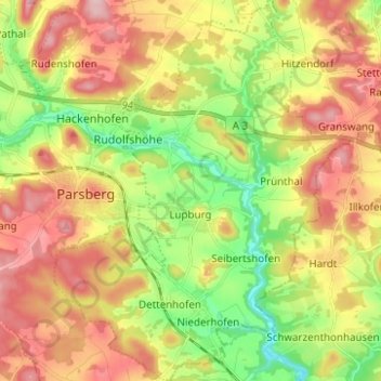
Name: Lupburg topographic map, elevation, terrain.
Average elevation: 1,667 ft
Minimum elevation: 1,385 ft
Maximum elevation: 1,959 ft
Make a donation
Gear up for your next adventure:
As an Amazon Associate, this site earns from qualifying purchases at no extra cost to you.