Geolocate

Fuping County topographic map

Click on the map to display elevation.

About this map

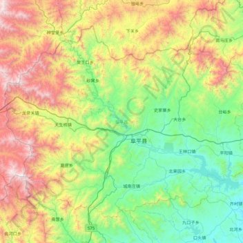
Name: Fuping County topographic map, elevation, terrain.

Location: Fuping County, Baoding City, Hebei, China (38.65569 113.75991 39.13320 114.53682)

Average elevation: 2,667 ft

Minimum elevation: 469 ft

Maximum elevation: 7,428 ft

Other topographic maps

Click on a map to view its topography, its elevation and its terrain.

Datai

China > Hebei > Baoding City

Average elevation: 1,283 ft

Bajiecun

China > Hebei > Baoding City

Average elevation: 75 ft

Panyingxicun

China > Hebei > Baoding City

Average elevation: 56 ft

Sanquzhuangcun

China > Hebei > Baoding City

Average elevation: 436 ft

Qiantangcun

China > Hebei > Baoding City

Average elevation: 112 ft

Gear up for your next adventure:

🕶️GPS Smartphone Mount - Secure mount for phone navigation
🛶Inflatable Kayak - Portable kayak for rivers, lakes, and expeditions
🧤Hiking Gloves - Protective gloves for rugged trails
🥇GPS Hiking Watch - Multi‑sport GPS watch with navigation and trail tracking
🔦Powerful Headlamps - Ultra-bright hands-free lighting for night navigation

As an Amazon Associate, this site earns from qualifying purchases at no extra cost to you.