
Ringing Rocks topographic map
Click on the map to display elevation.
About this map
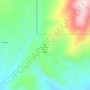
Name: Ringing Rocks topographic map, elevation, terrain.
Location: Ringing Rocks, Jefferson County, Montana, United States (45.94379 -112.23903 45.94389 -112.23893)
Average elevation: 5,584 ft
Minimum elevation: 5,013 ft
Maximum elevation: 6,745 ft
Jefferson County trails, hiking, mountain biking, running and outdoor activities
Other topographic maps
Click on a map to view its topography, its elevation and its terrain.
Boulder
United States > Montana > Jefferson County
Boulder lies at an elevation of 4,990 feet (1,521 m) above sea level along Interstate 15 at its intersection with Montana Highway 69, approximately 35 miles (56 km) north of Butte, and 27 miles (43 km) south of Helena. The town is on the north bank of the Boulder River, a tributary of the Jefferson River.…
Average elevation: 4,957 ft