
Make a donation
Gear up for your next adventure:
As an Amazon Associate, this site earns from qualifying purchases at no extra cost to you.
University Park topographic map
Click on the map to display elevation.
Make a donation
Gear up for your next adventure:
As an Amazon Associate, this site earns from qualifying purchases at no extra cost to you.
University Park
University Park was developed on land owned by the Deakins family since the mid-1700s. The house known as Deakins Hall or Bloomfield was constructed on the land in the 1820s or 1830s. It is located at 6404 Queens Chapel Road. The farm was purchased by the University Park Company in 1923. The extension of water and sewer lines into area at that time prompted the subdivision of the Deakins tract. The developers promised a community of single-family homes without the intrusion of commercial facilities. Restrictive covenants were placed on the deeds and all house plans had to be approved by the developers. Homebuyers were attracted to University Park due to its high elevation and lush vegetation. The developers also agreed to provide streetlights and trash removal for a 10-year period, and constructed a school in the mid-1920s.
Make a donation
Gear up for your next adventure:
As an Amazon Associate, this site earns from qualifying purchases at no extra cost to you.
About this map
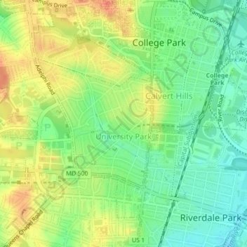
Name: University Park topographic map, elevation, terrain.
Average elevation: 95 ft
Minimum elevation: 16 ft
Maximum elevation: 187 ft
Prince George's County trails, hiking, mountain biking, running and outdoor activities
Make a donation
Gear up for your next adventure:
As an Amazon Associate, this site earns from qualifying purchases at no extra cost to you.