
Thank you for supporting this site ❤️
Make a donation
Make a donation
Gear up for your next adventure:
As an Amazon Associate, this site earns from qualifying purchases at no extra cost to you.
Duraznito topographic map
Click on the map to display elevation.
Thank you for supporting this site ❤️
Make a donation
Make a donation
Gear up for your next adventure:
As an Amazon Associate, this site earns from qualifying purchases at no extra cost to you.
About this map
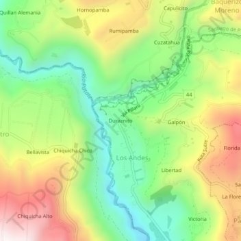
Name: Duraznito topographic map, elevation, terrain.
Location: Duraznito, Los Andes, Patate, Tungurahua, 180503, Ecuador (-1.26692 -78.53634 -1.22692 -78.49634)
Average elevation: 8,271 ft
Minimum elevation: 7,008 ft
Maximum elevation: 9,984 ft
Thank you for supporting this site ❤️
Make a donation
Make a donation
Gear up for your next adventure:
As an Amazon Associate, this site earns from qualifying purchases at no extra cost to you.