
Make a donation
Gear up for your next adventure:
As an Amazon Associate, this site earns from qualifying purchases at no extra cost to you.
San José de Chiquitos topographic map
Click on the map to display elevation.
Make a donation
Gear up for your next adventure:
As an Amazon Associate, this site earns from qualifying purchases at no extra cost to you.
San José de Chiquitos
La topografía es irregular, presentando serranías, llanuras, bosque amazónico y chaco.
Make a donation
Gear up for your next adventure:
As an Amazon Associate, this site earns from qualifying purchases at no extra cost to you.
About this map
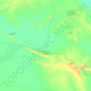
Name: San José de Chiquitos topographic map, elevation, terrain.
Location: San José de Chiquitos, Chiquitos, Santa Cruz, Bolivia (-18.41661 -61.26366 -17.00905 -59.52020)
Average elevation: 1,076 ft
Minimum elevation: 653 ft
Maximum elevation: 4,239 ft
Make a donation
Gear up for your next adventure:
As an Amazon Associate, this site earns from qualifying purchases at no extra cost to you.
Other topographic maps
Click on a map to view its topography, its elevation and its terrain.
Make a donation
Gear up for your next adventure:
As an Amazon Associate, this site earns from qualifying purchases at no extra cost to you.