
Kutztown topographic map
Click on the map to display elevation.
About this map
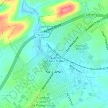
Name: Kutztown topographic map, elevation, terrain.
Location: Kutztown, Berks County, Pennsylvania, United States (40.50884 -75.79863 40.53458 -75.76387)
Average elevation: 466 ft
Minimum elevation: 390 ft
Maximum elevation: 673 ft
Berks County trails, hiking, mountain biking, running and outdoor activities
Other topographic maps
Click on a map to view its topography, its elevation and its terrain.
Pricetown
United States > Pennsylvania > Berks County > Ruscombmanor Township
Average elevation: 784 ft
Stony Creek Mills
United States > Pennsylvania > Berks County > Lower Alsace Township > Pennside
Average elevation: 630 ft
Hawk Mountain
United States > Pennsylvania > Berks County > Windsor Township
Average elevation: 1,142 ft
Highland
United States > Pennsylvania > Berks County > South Heidelberg Township
Average elevation: 692 ft
11th and Pike Playground
United States > Pennsylvania > Berks County > Reading
Average elevation: 433 ft
Maple Grove Park
United States > Pennsylvania > Berks County > Brecknock Township
Average elevation: 650 ft
Morgantown
United States > Pennsylvania > Berks County > Caernarvon Township
Average elevation: 620 ft
Albany
United States > Pennsylvania > Berks County > Albany Township > Kempton
Average elevation: 538 ft
Hawk Mountain
United States > Pennsylvania > Berks County > Windsor Township
Average elevation: 1,142 ft
Morgantown
United States > Pennsylvania > Berks County > Caernarvon Township
Average elevation: 620 ft
Hamburg Reservoir
United States > Pennsylvania > Berks County > Windsor Township
Average elevation: 1,112 ft
Tulpehocken Creek
United States > Pennsylvania > Berks County > Penn Township > Pleasant Valley
Average elevation: 364 ft
Shartlesville
United States > Pennsylvania > Berks County > Upper Bern Township
Average elevation: 600 ft
Morgantown
United States > Pennsylvania > Berks County > Caernarvon Township
Average elevation: 620 ft
Barto
United States > Pennsylvania > Berks County > Washington Township > Barto
Average elevation: 571 ft