
Make a donation
Gear up for your next adventure:
As an Amazon Associate, this site earns from qualifying purchases at no extra cost to you.
Twin Sisters topographic map
Click on the map to display elevation.
Make a donation
Gear up for your next adventure:
As an Amazon Associate, this site earns from qualifying purchases at no extra cost to you.
About this map
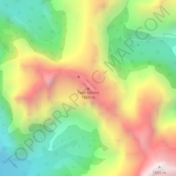
Name: Twin Sisters topographic map, elevation, terrain.
Average elevation: 3,409 ft
Minimum elevation: 1,247 ft
Maximum elevation: 6,115 ft
Make a donation
Gear up for your next adventure:
As an Amazon Associate, this site earns from qualifying purchases at no extra cost to you.
Other topographic maps
Click on a map to view its topography, its elevation and its terrain.
Darran Mountains
New Zealand > Southland > Southland District > Fiordland Community
Average elevation: 2,989 ft
Skippers Range
New Zealand > Southland > Southland District > Fiordland Community
Average elevation: 1,952 ft
Wick Mountains
New Zealand > Southland > Southland District > Fiordland Community
Average elevation: 3,888 ft
Mararoa River
New Zealand > Southland > Southland District > Fiordland Community
Average elevation: 2,234 ft
Make a donation
Gear up for your next adventure:
As an Amazon Associate, this site earns from qualifying purchases at no extra cost to you.
Lake Quill
New Zealand > Southland > Southland District > Fiordland Community
Average elevation: 4,029 ft
Lake Te Au
New Zealand > Southland > Southland District > Fiordland Community
Average elevation: 1,959 ft
Donne Glacier
New Zealand > Southland > Southland District > Fiordland Community
Average elevation: 5,991 ft
Age Glacier
New Zealand > Southland > Southland District > Fiordland Community
Average elevation: 5,751 ft
Make a donation
Gear up for your next adventure:
As an Amazon Associate, this site earns from qualifying purchases at no extra cost to you.
Cleddau River
New Zealand > Southland > Southland District > Fiordland Community
Average elevation: 2,625 ft
Pembroke Glacier
New Zealand > Southland > Southland District > Fiordland Community
Average elevation: 3,973 ft
Pitt River
New Zealand > Southland > Southland District > Fiordland Community
Average elevation: 2,316 ft
Milford Sound
New Zealand > Southland > Southland District > Fiordland Community
Average elevation: 2,149 ft
Make a donation
Gear up for your next adventure:
As an Amazon Associate, this site earns from qualifying purchases at no extra cost to you.
Doubtful Sound
New Zealand > Southland > Southland District > Fiordland Community
Average elevation: 1,837 ft
Long Burn
New Zealand > Southland > Southland District > Fiordland Community
Average elevation: 2,365 ft